
Short description: The goal of the project is to develop a device, which uses electromagnetic waves to detect buried objects and develop a software, which will analyze acquired signals in order to provide automatic detection of buried mines. The developed device will be based on a ground penetrating radar (GPR) techniques and will be attached to a flying device – hexacopter. The device with radar will capture 3 meters wide area, penetrating up to 2 m below surface and moving with a constant velocity. The principle of GPR is shown in the picture below:
GPR is a geophysical method that uses radar pulses to image the subsurface. It can be used in a variety of media, including rock, soil, ice, fresh water, pavements and structures. A GPR transmitter emits electromagnetic energy into the ground. When the energy encounters a buried object or a boundary between materials having different dielectric constants, it may be reflected or refracted or scattered back to the surface. A receiving antenna can then record the variations in the returning signal.
Within this project we have developed s stepped frequency radar and pulse domain radar, which operates in frequency and time domains, respectively. Both radars were tested on a mine field and they were attached to the hexacopter. The proposed timeline of the project was achieved and all activities within the project were successfully finished.
Within this project in the first year we have studied principles of GPR, generally in order to understand image interpretation and later we spend a lot of effort to simulate a GPR using a USRP that was challenging due to the hardware design of the USRP. We made some hardware simulations and start to design a hardware for GPR. The frequency domain radar was developed that uses standard telecommunications components and it operates within a frequency range of 500MHz-2.7GHz. Radar uses a step frequency principle and can generate a sweep of frequencies within 10 ms using 200 frequencies. A time domain radar was also developed using a ultra-wide band principle. It showed good results for ground-based radar, but did not well performed, when it was attached to the hexacopter due to the high reflection from the ground and bad penetrating, when distance between antenna and ground was above 0.5m. We made several tests using sparse frequency radar and it is very useful principle, because only 60% of generated frequencies are needed to form an image using compressed sensing principled.
Within the third year we developed a software for online transmission of data form hexacopter to the PC and onboard storage of the data. A Synthetic Aperture Radar principle was developed and tested for better object representation. They could geocode a product using GPS data to depict radargram in geolocation. This part is still under development and will be finished soon.
We have tested a software with potential the end user in Macedonia at Military Academia and there was a big interest for such device in Slovenia from a demining centre.
Radar attached to the hexacopter is fully operational and it is possible to fly over the landmine field and detect buried objects.
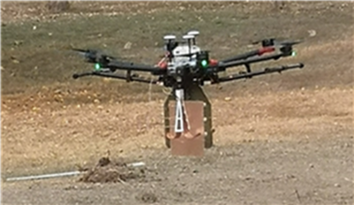
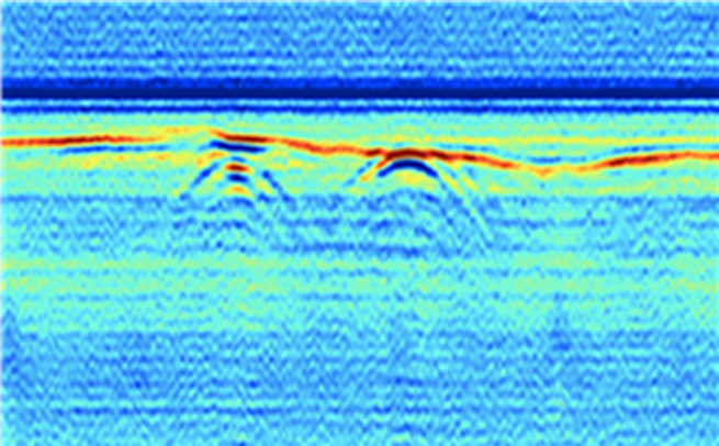
Figure (below): Antennas and small GPR attached to the hexacopter. (under): Detected buried object detected using stepped frequency radar
The goal of the project was to develop or use:
- Ultra wide band antennas
- Design stepped frequency radar
- Represent GPR data and detect landmines.